Penn Pike Itinerary
Day 1


“A journey is a person in itself; no two are alike. And all plans, safeguards, policies and coercion are fruitless. 

We  find after years of struggle that we do not take a trip : a trip takes us.” 
                                         - John Steinbeck 

- - - Updated July 9, 2002 - - -


  • Leave Home - - "0-darkthirty"

  •  
  •  Meet along the way

  • To caravan, the easiest place to meet would be on Ohio Turnpike at the last Service Area in Ohio near Pennsylvania Line { Ohio T-pike Marker #237), just past Exit 16 [Ohio Rte 7])see map
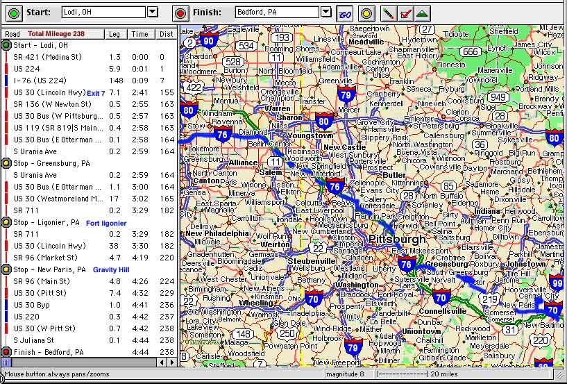
  •    - To coordinate a meeting time of 9:30 A.M., I am guessing you need to leave at the below
          suggested times:
  •  Dad   (8:00 A.M.) - 1 1/2 hrs to meeting point
  •  Brian (8:30 A.M. ???)
  •  John - 119 miles @ 65 mph = 1.8 hrs  (7:42 A.M. ???)

  • - If john is towing bike trailer, we need to work that out ahead of time
  • Then we will take the Ohio & Pa Pikes to. . . . .

  •  
  • Exit 7 of the Pa Turnpike, (meet Chris & Coop) then follow Route 30 through some of the many beautiful spots in the world. Places like:

  • Lincoln Heights, Greensburg, St. Vincent Shaft, Rock Hollow, Buttermilk Falls, Laurel Highlands, Buckstown, Grandview, Negro Hollow,
    Estimated distance to campground - 85 miles (additional 2- 3 hours)
     
     
    Overview Map - Lodi to Bedford 
    Overview Map - Exit 7 to Bedford
    Map Page
  • Stops ???  - Fort Ligonier - Ligonier, PA
  • Stops ???  - "Along The Way" -PBS Special
  • Stops ???  EAT Lunch at a "Diner" - - Examples - - - 
  • Stops ???  Gravity Hill (may set-up camp on Day 1, then return)

  •                          [https://pennpike.tripod.com/day1itin.html]
  • http://popmail.med.nyu.edu/~strone01/gravity.html
  • http://www.bedfordcounty.net/GRAVITYHILL/  (directions)
  • Some of what we may see on Route 30

  • The following is a from friend of Jennie's & Chris'. I have some of his books.
  • Photos (long download) this kind of sums up what I would like to see along the way


  • (Lincoln Highway links)

  • Diners
  • Isaly's
  • http://www.lhhc.org/content/subpag/thehi.htm
  • http://www.sphpc.org/path/bed.htm
  • http://www.lhhc.org/

  • http://www.lhhc.org/content/subpag/ship.htm 
    (burnt down 2001)
    I "want to" see the old Pa pike ( by bicycle), 
    but I do not sure I am up to it. . but I am going to try it.
    - - -  see bike - - -


    Gravity Hill
    - maps -


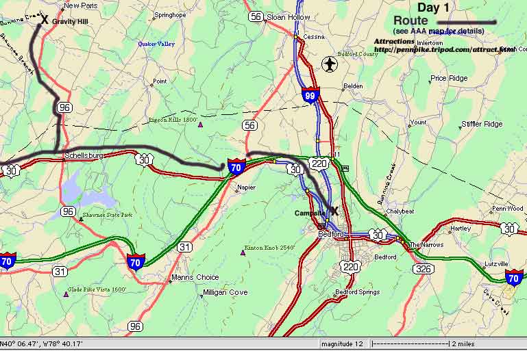
    From route 30 in Bedford County Pennsylvania drive to the town of Schellsburg which is about 8 miles west of Bedford.  In Schellsburg, turn north onto Route 96 at the one-and-only traffic light (towards the town of New Paris).  Drive about 4 miles on Rt. 96.  Before you come to the town of New Paris, you'll come upon a small metal bridge.  The sides of the bridge are metal ... the road surface is paved.  Turn left just before this bridge onto Bethel Hollow Road or S.R 4016.  Drive for 6/10th of a mile and bear left at the "Y" in the road.  (Stay on the "main" road).  After another 1 1/2 mile, you'll come to an intersection that has a stop sign (for on-coming traffic only).  Bear right onto this road and drive 2 tenths of a mile and look for the letters "GH" spray painted on the road.  Go past the first "GH" about .1 mile and stop before you get to the second spray painted "GH".  This is it.  You have arrived.
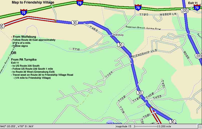


    Directions to campground


    From PA Turnpike 
  • Exit 11 
  • to US Route 220 South 
  • Follow US Route 220 South 1 mile to Route 30 West (Greensburg Exit)

  •  
  • Travel west on Route 30 to Friendship Village Road (1/4 mile to Friendship Village)


  • see map


    E-mail fellow travelers