The following directions, comments, advice were sent to me by the
authors I have indicated in the text.
| from Rush Wickes. . .
I did the trip through the two abandoned tunnels on foot in May.
I would suggest that the best way to access the Sideling Hill tunnel would
be from the east end. This would be reached by turning
off Pumping Station Road at the overpass for the old roadway and parking
along what was the access road for the old Cove Valley service area.
All that would need to be navigated would be one or two jersey barriers
placed across the road - I believe they can be squeezed around on
bike or foot.
I would advise against trying to enter/leave
the roadway at SR 1011 (Mountain Chapel Road, I believe is the name).
At this point, the old road passes over SR 1011 on an overpass, with _very_
steep embankments and no visible alternative. I believe one can safely
access the old Turnpike from the south end in Breezewood, just behind what
is now a Ramada Inn parking lot.
The grades seemed to be quite reasonable around Rays Hill and the
Sideling
Hill tunnels. However, there is some rolling terrain
on the stretch
between them. Be advised that the surface quality of
the route will be
rather rough in most stretches. Have fun!
======================
Here is
a map of how to get to the old Sideling Hill Tunnel on the long abandoned
stretch of the PA Turnpike.
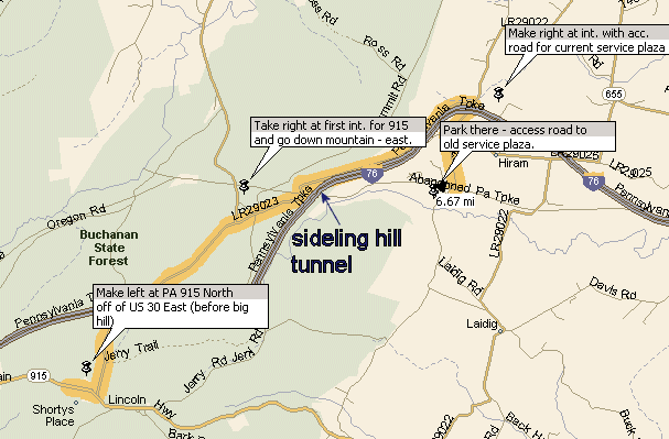
Heading out of town on US 30 east from Breezewood - go up the
mountain and cross over the modern Turnpike on an overpass.
Continue up the hill and watch for PA 915 North, which will join up with
US 30 briefly and then turn off to your left. Make a
left onto PA 915 North at this point and follow it across another overpass
over the modern Turnpike. Then, you will see an intersection
(a fork, I believe), with a road to your right. Take this road
to your right and follow it down the mountain -- soon you will be paralleling
the modern turnpike on the northern side.
At the base of the descent -- you will come to a 4 way intersection
with the worker entrance to the existing PA Turnpike service plaza ahead
of you and a road passing underneath the existing turnpike to your right.
Make a right here and proceed under the turnpike -- headed south.
About a mile later, the road will come to a four way intersection -- with
the primary direction of travel turning off to the left -- you want to
continue straight - going onto 'Pumping Station Road'.
Follow this road for about 1.5 miles until you come down a small hill and
see
an overpass - this is the old Turnpike.
Make a right on what appears to be a small driveway just before reaching
the underpass -- this was the access road to the old Cove Valley Service
Area. Continue up the driveway until you reach a jersey barrier
that has 'no vehicles' stenciled in orange day-glo paint on the top.
Park here and take your bikes around the barriers and continue up
for about a 1/2 mile or so. You will come into the old service
area - which later served as a firing range for the State Police (don't
worry, it has long been inactive, despite the warnings still posted).
You will find the Sideling Hill Tunnel about 2 miles north of Cove Valley
on a very gentle, if roughly paved incline. Have
fun!!
Map |
| From Koerner:
I am not sure of the best pick-up/drop off points for the abandoned
section, as I have visited that section only once and then only
for a
few short minutes (I was on the way home from an east coast roadtrip
last summer). I would have *LOVED* to have been able to spend
a day. I
walked in from a crossroad off US 30 just east of Breezewood, a
place
that was decidedly NOT handicapped-accessable (it was the sideroad
by
the west portal of Ray's Hill Tunnel).
For a place to park, I would check with the people who are currently
busy with the trail conversion. They are working as quickly
as their
financial resources will allow. I believe (but am not certain)
that
they do have a link somewhere on the Turnpike's official website.
This
is the first EVER 'interstate highway-to-trail' conversion and I
*WANT*
to check it out for myself!
The section between the tunnels has fairly normal grades, similar
to the
rest of the highway. The USGS topographic maps on my website
(or at the
Microsoft Terraserver or Topozone websites) should offer more specific
information. That section IS part of the old 'almost' railroad
grade,
too. Just make sure that you can 'downshift' with your bicycle
and
don't worry about not being able to be a speed demon, just go at
your
own pace and enjoy the experience.
Good luck!
I will be forwarding your query to the Usenet newsgroup
'misc.transport.road', as there are several regulars in there who
also
have experience in that part of the USA. |
John,
Glad to hear from you again. Hope you enjoy your trip to the tunnels.
The area between Ray's and Sideling is relatively flat. And I say
relative,
I'm not sure what the nature of your handicap is, but keep in mind
a few
things. You're relatively high, if I remember about 4-5,000 ft,
so the air
is thinner than at sea level. In July it can be brutally hot. The
last time
I was there in July it was over 90 degrees. Early morning may be
best if you
have heat problems.
If you go into the forums, there are directions to the tunnels, including
how to get to the area between Sideling and Rays. I have only viewed
that
section, not travelled it.
Have fun.....
John Barrick |
| John,
Did you check out these directions in person? Specifically
the "Pick Up
Point"? But also the "Drop Off Point".
I could be mistaken, but I think the road at the pick up point goes
under the turnpike, and there is NO access except to climb up (or
down) a STEEP hillside.
I climbed up to the turnpike and I think it was at that spot.
And it was
NOT an easy thing to do. I kept sliding back down.
Also, for the Drop off point, we went to the NEXT road (than you
mention) and drove OVER the tunnel, then turned on the same road
you mention but from the other end. And got to the Oregon
Camp
from the opposite direction. If you haven't checked it out,
I think that
would be easier.
I'm at work right now. Let me check it out more carefully from
home
and I'l write again.
- Charlie
Amusement Park Nostalgia
====================
John,
To try to clarify the second part of the last message.
The road you highlight from Rt 30 to Oregon Camp, if I remember
right is a VERY narrow, steep, potholed DIRT road, mostly up high
on
the side of a hill. It is a very nerve-wracking road to drive.
At least
the first half of it.
At the spot where you have it touching the turnpike (about 2/3's
of the
way along your highlight) it's a pretty level dirt road from there
to
Oregon Camp.
I would suggest taking Rt 30 further East to the next road (Rt 975,
I
think your map calls it), and take that over the tunnel to the next
dirt
road, which will take you to Oregon Camp from the other direction.
If I remember right, there's a LITTLE tiny sign on the side of the
road
just as you're passing over the tunnel. It mentions that the
tunnel is
just underneath. IF you can find the sign, look for the next
dirt road
on the left.
I hope that clarifies it a little.
- Charlie
Amusement Park Nostalgia |
|
|
|
The following directions, comments, advice were "borrowed" from John
Barrick
(j_barrick@hotmail.com).
West to East
To Laurel Hill Tunnel - EXIT 9
The western portal of Laurel Hill tunnel is easily visible
if you stop your car on the eastbound side of the turnpike at MP 99.2.
This is between Donegal (exit 9[milepost
90.7]) and Somerset (exit 10). Off to the right side of the
turnpike you'll see a service road which intersects with the old right-of-way.
This portal was being used as a salt storage area when I was last there
in October of 2000.
The eastern portal of Laurel Hill requires either a long hike (1
mile) from a remote area or trespassing from the current right-of-way in
full view of any troopers on the turnpike. I'm not going to go into that,
there are much easier pickings at Ray's Hill and Sideling.
(ed note)
- if you would like to explore Laurel Hill (which I highly
recommend), please take a look at: https://www.angelfire.com/wv/joyrde/papike.html
My
family and I made this a couple of years ago. As some who is handicapped,
I can honestly say that the hike is not that bad.
To Rays Hill & Sideling Hill - EXIT
12
-  Topographic Map Site
-
Print ready topographic map
Topographic Map Site
-
Print ready topographic map
To get to the western portal of Ray's Hill, take Rt 30 east of of Breezewood[milepost
161.4] up the mountain. You'll get to a road on the
left (ed. note SSR 1011)that
goes to the western portal of Ray's Hill. I think it's the only road off
to the left (ed note:on
the map there are two lefts . SSR 1011 is the second left) .
You'll see an overpass, kind of Art Deco rounded corners, you'll recognize
it as vintage turnpike. Climb a short hill and you're right there.
To get to the area between Rays Hill & Sideling Hill is easy.
Take Rt 30 east out of Breezewood up the mountain, past the road to the
left that goes to the western portal of Rays Hill. When you are up on top
of the mountain, the road (Rt 30) will be relatively level, and you'll
be traveling parallel to the new turnpike. There will be a gravel road
that will be on your left (heading north [ed
note Oregon Road???]). It will
go under the new turnpike, and you can see this overpass from Rt 30. I
think its the only such road, so you shouldn't mistake it.
Go on this road under the underpass. A short distance after the underpass
you have to turn either left of right. Go left to Rays Hill (A below) or
right to Sideling Hill (B below).
-
This road loops around, heading west initially, then turning north,
and finally heads back east. It goes to some kind of a camp. When you are
at the lowest point and heading north, you are directly over Rays Hill.
You can hike directly down the hill there (heading east), and you'll end
up on top of the tunnel entrance. (There is no fan house at this end of
Rays Hill, just a concrete wall.) Look behind this concrete wall for the
old stone wall that was there for the railroad. Alternatively, if you back
up on the road, you might still be able to see the remnants of an access
road that also goes down to the tunnel. This was getting pretty badly overgrown,
so it might be hard to see. This road went past a transformer pad (long
gone) and kind of comes down alongside the tunnel and eventually joins
the old roadbed. This road is pretty narrow and not travelled much. If
you have trouble turning around, continue on it to the camp. Also, the
point over Rays Hill should be obvious, because this is the apex of the
loop and the road will be turning more sharply.
-
Follow this road for several miles. You'll be gradually be going down
hill, and eventually you'll get down to the elevation of the old roadbed
and you'll see it off to your left. Then you pass under it. Maybe 1/4 mile
past this overpass, you'll see what appears to be a forest ranger's camp.
It'll look like a log cabin. Park there, and look for a trail that goes
off behind these buildings and a little to the left. Since you are now
north of the old highway, you'll be heading roughly 170 degrees by
the compass. There was a gate across it last time I was there to keep vehicles
out. This trail was an access road to Sideling Hill. I never paced this
trail, but it isn't too far until you'll come up to the old road and from
there you can see the tunnel. You'll pass some old sheds on this trail;
I think these were home of the wrecking/breakdown crew that was staged
here at all times, at least in the summer, to clear out "problems" blocking
the single-lane tunnel.
To get to the eastern portal of Sideling Hill, and the old Cove
Valley service plaza, continue on Rt 30 east until you come to a road called
"Pumping Station Road" (how appropriate!). Go down there, probably about
4-5 miles. It will change surface (gravel/asphalt) several times. You will
come to an underpass which is the old right-of-way. Before the underpass
will be an old access road, blocked off with temporary concrete median
barriers. From there you can go left and walk on the old right-of-way,
or continue under the underpass to another service road. This is the old
road where tanker trucks delivered fuel to the service plaza. The plaza
has been torn down, but the parking area and access roads remain. Please
be careful, when we were there in 1997 there was a sign at the old service
plaza that said it was a shooting range. I heard no shots but I wouldn't
wander in there. About a mile down the road after the service plaza is
the eastern portal of Sideling Hill.
Good luck exploring on your trip. Again, please leave a reply to
this thread if you use these instruction and let everyone know how your
trip went. If you post pictures on the web, if you include a link to my
site and send me an e-mail, I'll add a link to my site.
"click"
to reply to John Barrick
"click"
to contact
John Stephens
|
